
 4.4
4.4


Google Earth App Info


Introduction
Google Earth is a virtual globe, map, and geographical information program developed by Google. This app allows users to explore the world from above using satellite imagery, aerial photography, and 3D terrain. It was first released in 2001 and has since become a popular tool for educators, researchers, and explorers alike. With its constantly updated maps and user-friendly interface, Google Earth has revolutionized the way we view and understand the world around us. The application is available for desktop and mobile devices and is easy to use for both beginners and advanced users.
Features of Google Earth
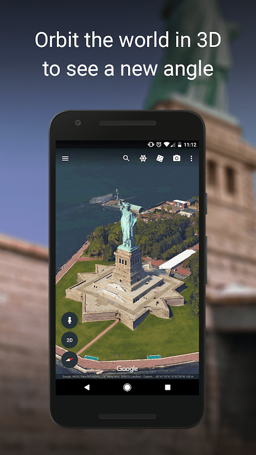
![]() Explore the world in 3D
Explore the world in 3D
Google Earth allows users to explore the world in 3D, giving a more immersive and realistic experience. Users can navigate through cities, landmarks, and natural wonders in 3D, and even tilt the view to see the terrain and buildings from different angles.
![]() Street View
Street View
One of the most popular features of Google Earth is Street View, which allows users to take a virtual walk down the street and see the surroundings as if they were there in person. This feature is available in many cities and allows users to explore neighborhoods, landmarks, and businesses.
![]() Measure distance and area
Measure distance and area
Google Earth has a built-in measuring tool that allows users to measure the distance between two points or the area of a particular location. This feature is useful for planning trips, calculating property boundaries, or simply satisfying your curiosity.
Highlights of Google Earth
![]() Create your maps
Create your maps
Google Earth allows users to create their custom maps by adding markers, lines, and polygons. This feature is useful for planning a trip or highlighting points of interest for research or educational purposes.
![]() Historical Imagery
Historical Imagery
Google Earth offers historical imagery that allows users to see how a location has changed over time. This feature is useful for research, educational purposes, and even genealogy.
![]() Sky View
Sky View
Google Earth includes a Sky View feature that allows users to explore the night sky, stars, and constellations. This feature is useful for astronomy enthusiasts or for educational purposes.
![]() Tour Creator
Tour Creator
Google Earth’s Tour Creator allows users to create their own virtual tours of a particular location or landmark. This feature is useful for educators, travel enthusiasts, or anyone who wants to share their experiences with others.
Tips
![]() Explore Different Layers!
Explore Different Layers!
Google Earth has various layers that you can use to explore different aspects of the world. You can choose from different layers, such as 3D buildings, roads, terrain, and even historical imagery. These layers help you understand the world in different ways, from geographical features to the growth of cities over time.
![]() Fully Utilize the Search Feature.
Fully Utilize the Search Feature.
Google Earth has a search feature that allows you to find specific locations around the world. You can use it to find a specific address, city, landmark, or even a natural feature such as a mountain range or a lake. The search feature also allows you to switch between different views such as satellite, street view, and 3D view.
![]() Create Custom Tours!
Create Custom Tours!
Google Earth allows you to create custom tours of specific locations or routes. You can use the “Tour” feature to create a flyover of a specific location, create a narrated tour, or even record your own voiceover. This feature is great for educators, travelers, or anyone who wants to share their experiences with others.
Pros & Cons
 Google Earth provides high-resolution satellite images of the entire world.
Google Earth can help plan a trip by allowing users to explore new places.
Google Earth is an excellent educational tool with a wealth of information related to geography.
Google Earth provides high-resolution satellite images of the entire world.
Google Earth can help plan a trip by allowing users to explore new places.
Google Earth is an excellent educational tool with a wealth of information related to geography.
 It requires an internet connection to use.
It can be resource-intensive on some devices.
It requires an internet connection to use.
It can be resource-intensive on some devices.
FAQ


Ratings